Friday, October 31, 2014

Redding Living

October 31, 2014

Redding Living

We began our Redding Living with bright blue skies and temperatures in the low 70's, a welcome respite after spending our last few days in Oregon in rain, clouds and fog.

The weather began to clear the morning we left Grants Pass, heading south over Siskiyou Pass towards northern California.

We spent the first afternoon setting up the coach, and then making a grocery run. It was nice to be close to shopping again after spending a month "18 miles from Walmart" (RVers gauge for how close a campground is from shopping facilities).

The next morning was cleaning time. We track in a lot when we're breaking down and setting up. We also get a lot of dust when we leave windows open, which we were able to do in Oregon, so it was time for a good sprucing up.


With the "house" clean and Jo's sewing corner set up and ready, it was time to check out what was around our new "home place".

Naturally we were drawn back up the road a little ways to Mt Shasta, the dominate mountain in the Redding area we had seen on the way in. We picked out a route that took us east, then north to Mt Shasta and back to Redding, about a 140 mile loop. We made a short side trip to Moose Camp, a private camp on the way to Burney where we would turn back to the west. 
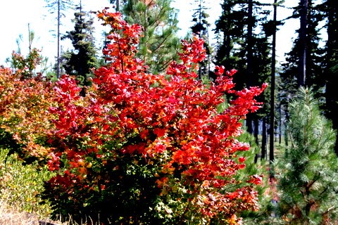

We found some great fall color and the brightest red maple either of us had ever seen. See Jo's pics on her Pinterest page ( http://www.pinterest.com/jimcope/ ) .

Driving up and down on beautiful mountain roads, we finally turned west again at Burney toward Mt. Shasta. 


We stopped at a great waterfall. 


 Then on towards the mountain. Our first view from this direction, the mountain was shrouded with smoke at the it's base from controlled burns by the forest service. 

After passing through the burn area, the mountain came into view again, minus the smoke. It was a little tricky finding good vantage points along the heavily forested highway, until we came into the small town of McCloud. 


This quaint picturesque little town is dominated by it's view of Mt Shasta. After taking a few shots, not only of the mountain, but also of the town itself, we moved on towards Shasta City, and the interstate back to Redding.


On the way we took a side road to the right, driving up as far as we could toward a ski resort which was still closed before season opening. Snow down to 4000 feet is in the forecast in a couple of days, so opening of the ski area could come soon. The road gave us several views of Mt Shasta with reflected sun from the sunset.


It was getting dark when we made it back to Shasta City and it's pretty neighborhoods, so we will have to make a return trip there.


The next day was spent with Jo tweaking her sewing center and editing photos, while I worked on writing a few pages for the website. At the end of the day, needing to get out, we drove a couple of miles to the Redding Sundial Bridge, where we walked and took more photos. 


We aren't sure whether the bridge is a marvel in architecture, engineering or art, but it has elements of all three and is beautiful. The grounds around the bridge spanning the Sacramento River, are perfect for a stroll.


We had decided to spend another day at home the next day, but with rain in the forecast , (snow in the higher elevations) we decided to try to make one more little side trip, this one to Whiskeytown Recreation area. It's a nice forested area just a few miles west of Redding. We stopped at a picnic table as we drove around the lake and had lunch. 


Then we continued the drive around the lake through large forests, along a stream, and across open hills covered with Manzanita shrubs. 


Jo found a forest service road that took us past some great views of Whiskeytown lake. We arrived back home at dusk and enjoyed a great "leftovers" dinner.


Redding sits in a valley surrounded by the Coastal mountains to the west, the Cascades to the north, and the Sierra Nevada range to the east. We are starting to feel "right at home", and it's only been a few days. It is a blessing to be able to live here for awhile.


Thursday, October 16, 2014

The Dexter Lake Club and "Animal House"

October 16, 2014

"Dexter Lake Club and Animal House"


Last night we had dinner in the Dexter Lake Club, featured in the road trip scenes in the movie Animal House. We ate in the cafe, and had a pretty good meal (too much garlic). Then we just peeped into the bar long enough to see the sound stage, the zebra wallpaper, and hubcaps on the wall behind where Otis Day and the Knights played (they still do).


Afterwards, we rented the movie to see if we recognized anything that we had just seen, but after a few minutes, the language and the sexual innuendos became less than humorous....... So we switched over to an episode of "The Walton's" (such party animals we are).......Guess we'll never know much more about "Animal House". But for what it's worth, and for all you fans, we went to the place of the original movie set, and the Deathmobile still sits out front......


Monday, October 13, 2014

Row, Row, Row your boat......

October 13, 2014

During our month here at Dexter Shores RV Park, we have been privileged to be able to watch the University of Oregon's Rowing Teams practice here on Dexter Lake across from our campsite.


They have been out nearly every afternoon and, are very competitive as they move across the water.  There are both women and men's teams.  The teams are made up of either 4-man and 8-man crews plus a coxswain (coach and navigator).


The Oregon team has high national standings in rowing and regularly has wins or places high in their races.


The Covered Bridge Regatta is this Saturday. We are looking forward to seeing the teams in action.


Sunday, October 12, 2014

Autumn Oregon

October 9, 2014

With reports coming in of peak color in Willamette National Forest, we decided to take a drive in the direction of Sisters, Oregon which is on the eastern edge of the Willamette Forest.


Our route took us from Eugene, east on Hwy 126, over Santiam pass on Hwy 20/126 to Sisters. After driving around Sisters, and of course, stopping at a quilt shop, we looped around to Hwy 242 and returned by way of McKenzie Pass to Hwy 126, and back toward Eugene.


The October day was bright and sunny, with a blue sky, and a few high Cirrus clouds in places.


The first peak color we noticed was near the junction of Hwy 126 and Hwy 20.


The contrast of the colorful yellows, oranges, and reds against a backdrop of evergreens was awesome. The drive up toward Santiam Pass was spectacular. Throw in a few waterfalls, small lakes, and towering distant mountains, and it get's hard to take a bad photo.


 Good mountain views of Three Fingered Jack, Broken Top Mountain, and Mount Washington were frequent.

Along the Santiam Pass leg of the loop we made stops at Sahalie and Koosa Falls, beautiful water falls worth the short walks to view.


Clear Lake was lined with colorful foliage with kayaks matching the colors of the leaves.


A side road to Hoodoo ski area and Big lake gave us great views of Mount Washington.


Camp Sherman with it's popular general store was worth our brief stop.


The nearby headwaters of the Metolius River, with it's waters bubbling up from the ground, and it's view of Mt Jefferson looming in the background, was reached by a nice short walk on a paved path between rustic fences.


The town of Sisters, with it's art galleries, antique stores, and boutiques is popular and quaint.
It is home to a well known rodeo, an incredible outdoor quilt show, and a popular folk music festival at other times of the year.


The three sisters peaks, (Faith, Hope, and Charity) tower above the town.


Picking up Hwy 242, we started the second leg of our drive over McKenzie Pass. The road is narrow and winding with good views of forest and vistas. Windy Point turnout gave us our first view of the 65 square mile lava fields.


I was not prepared to see lava fields, and turning the corner and seeing it for the first time made me feel as if I had landed on another planet.


Miles of jumbled rock as far as you can see was a stark contrast to the forest, lakes, and streams we had just been through.


The summit of McKenzie Pass puts you right in the middle of the lava fields. There is piled up lava rock literally in every direction. A short climb to the Dee Wright Observatory,


built in 1935 by the Civilian Conservation Corp, gives you an incredible "other world" view with six lofty mountain peaks ringing the lava fields.


Our drive down McKenzie pass gave us views of the best fall color of the trip. Every turn (and there were many) along the winding descent opened up the beautiful contrasts between the autumn colors and the dark green pine forests.


The last miles along the McKenzie River was a perfect finish to a perfect day. This was one of our best day trips.


Monday, October 6, 2014

More Covered Bridges

October 5, 2014


This part of Oregon has an abundance of Covered Bridges. We have visited seven within just a few miles of our RV park. The last one we discovered was less than two miles away.


Earnest Covered Bridge


Most of these bridges were constructed by the Lane Company during the 1920's. With good maintenance and attention to detail, they have stood the test of time.


Parvin Covered Bridge


The Howe truss method was used in the construction. With the Northwest's abundance of wood, this method was considered perfect..


Pengra Covered Bridge


 The Howe method uses short run timbers, and a smaller number of steel rods, both of which can be easily replaced when necessary.


United Covered Bridge


This results in strength, and quick, easy construction. Also the initial cost, as well as replacement costs of the individual truss parts is less. Truss parts can be erected quickly and cheaply.


Some reconstruction was done on some of the bridges in recent years at a relatively low cost.  All of the bridges shown here are still in use. It was a pleasure to drive across all of these bridges and imagine a different time.


In fact, it reminded me of a time when we could drive across Clarkston Covered Bridge near where I grew up in Alabama. Of course we had to challenge each other to see how fast we could drive across it......! Did you know your car could fly briefly when you came out of a dip and onto a bump in the sagging bridge?? ......Maybe that's why they closed it to traffic.....


There are forty more covered bridges around Oregon. We will keep looking for them. By the way, we still haven't seen the ones we are supposed to see on the covered bridge tour.....These are all different ones. We are still planning to take the tour......sometime.


Wendling Covered Bridge


Maybe we can even find some that don't look like all the others.....like this one.


Office Covered Bridge